
Some latest satellite imagery released in January this year revealed how mysterious constructions of military infrastructure have come up in Coco Islands in the Bay of Bengal.
The images uphold India’s long-held belief that China is increasing military activities on the Myanmar-controlled Coco Islands, one of South Asia’s most strategic islands, which India lost control of due to Jawaharlal Nehru’s lack of strategic comprehension and his inability to bargain hard with the Britishers.
The images that were captured by Maxar Technologies in January reveal that Myanmar may soon be intending to conduct maritime surveillance operations from Great Coco Islands.
According to media reports, the satellite images revealed new developments in the Great Coco Island region, including two newly-built hangars in the centre and a few new buildings in the north, as well as a large pier possibly for accelerating naval activities.
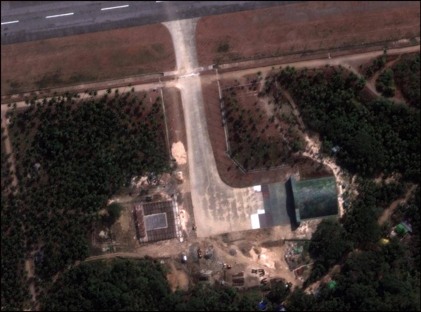
On March 31, 2023, Chatham House, an independent policy institute headquartered in London, published an article written by Satellite imagery expert Damien Symon, who goes by the Twitter handle @detresfa_, and foreign affairs and security issues expert John Pollock that read that the satellite images show that there are two new hangars, a new causeway, and what appears to be an accommodation bloc — all of which are visible in proximity to a newly lengthened 2,300-metre runway and radar station.
New construction activity on Myanmar’s Great Coco Island transforms the island from a subject of previous speculation into a possible security threat for India in the Andaman region – a deep dive with @John_Pollock22 @TheWorldTodayhttps://t.co/OTBfF4SeaY
— Damien Symon (@detresfa_) March 31, 2023
Visible as of late March on the southern tip of Great Coco, just beyond the causeway connecting the islands is evidence of land clearing efforts indicating construction work to come, the article read.
Chinese presence in Coco Islands
The Coco Islands give India an immense strategic advantage in the region, considering its proximity to the strait of Malacca which is a crucial point for the global supply routes of oil from the Gulf. With the reports of increasing military activities of China on the Myanmar-controlled Coco Islands, the region becomes another hotspot for potential Chinese notoriety.
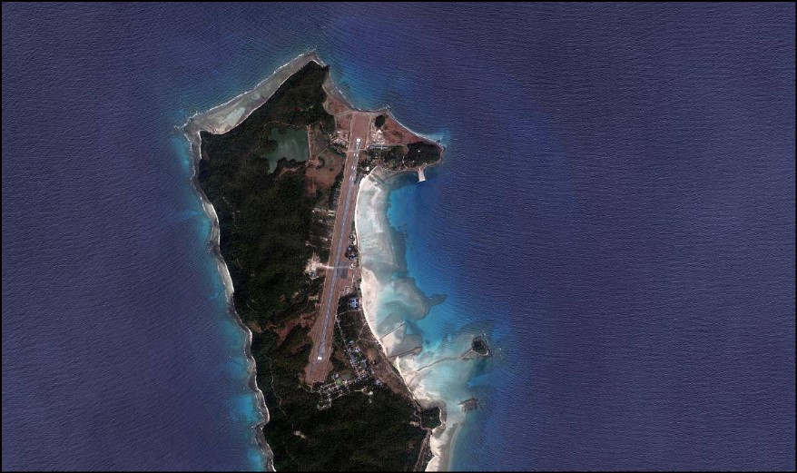
Coco Island, which is north of Andamans is strategically important to India. China, which has been eyeing to encircle India in the Indian Ocean Region with its aggressive ‘String of Pearls’ policy has shown keen interest in this island for the last four decades. Since the early 1990s, there have been frequent reports of China using those islands for military and naval purposes. There are even reports that the islands have been leased out to China in 1994, but Mynamar denies it.
It is, however, well known in defence circles that the islands, specifically the Great Coco Island, are under Chinese control and they have established a strong military presence there. They have signal intelligence facilities, maritime bases, and radar facilities that they use to monitor the activities of Indian armed forces, especially the Indian Navy based in nearby Andamans. The Great Coco Island had a short airstrip of around 1000 metres that allowed the operation of small aircraft. But the Chinese have now extended it to an almost 2500 metre runway, which is used solely for military planes as no civilian plane flies there.
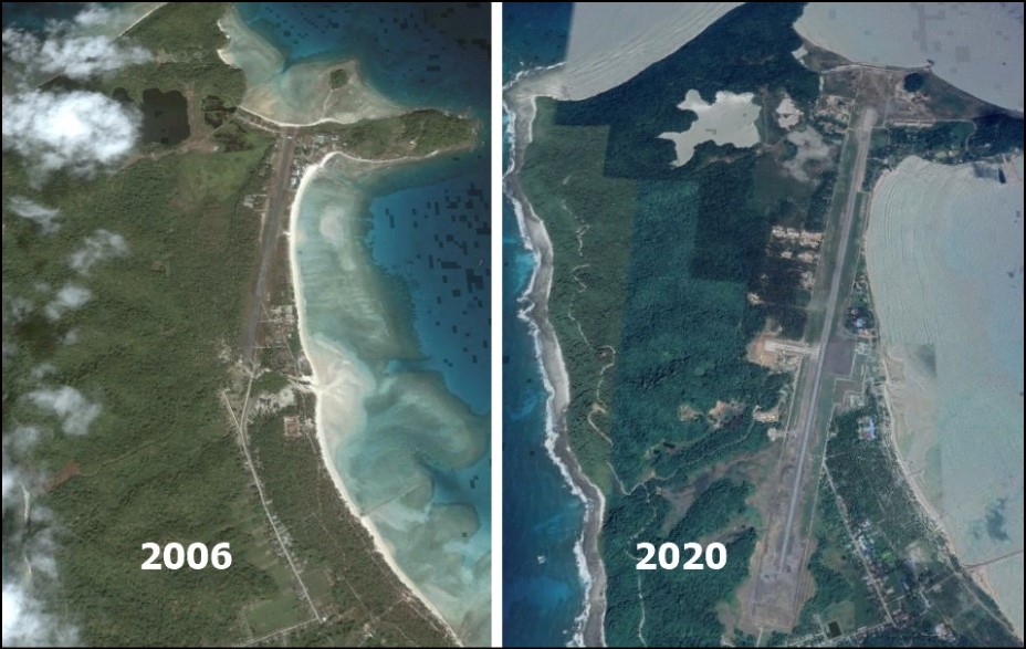
An analysis of satellite images shows that the runway was extended only 5-6 years ago when China increased its military presence in other countries. Apart from extending the runway inward, the Chinese also reclaimed lots of area on the coast to extend it towards the sea, which can be seen in the two images from Google Earth given below, from 2006 and 2020.
China has also installed a SIGINT facility to monitor Indian missile launches into the Bay of Bengal and the Indian Ocean. It is noteworthy that all Indian missile tests happen on the eastern coast along the Bay of Bengal, and thanks to the monitoring station at the island, now China can closely watch such launches and estimate even the classified details of the missiles, apart from being able to monitor movements of Indian navy.
The Radar station at the island is located at the highest point of the island at around 90-metre altitude, giving it the best monitoring capabilities.
Therefore, thanks to its strong military presence at the Coco Islands, the Chinese can maintain a close watch on India’s defence preparedness. Had the Island not gone to Myanmar and remained with India, China would not have such a strong military presence so close to India. Hence, not being able to retain Coco Islands cost India dearly, and it must be considered a costly strategic blunder by the Congress party under the leadership of former Prime Minister Jawaharlal Nehru.
