

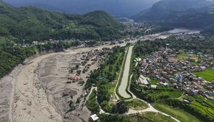
Five months before flash floods in Nepal killed 272 people, two major reports had already raised serious concerns about the rapidly changing conditions in the Hindu Kush Himalaya (HKH). The reports warned that glaciers were losing ice at a much faster rate, snow cover was shrinking, and parts of the Himalayan region could be moving towards critical tipping points. Now, as scientists investigate what triggered the deadly floods, many of the concerns highlighted in those reports have come back into focus.
Researchers are still trying to establish the exact cause of the disaster, but scientists believe several factors may have come together. One of the biggest concerns is that rain is now falling at altitudes of 4,000 metres and above, where snowfall was once more common.
A scientist at the central government’s Dehradun-based Wadia Institute of Himalayan Geology told NDTV on Thursday, 27th August, that rising temperatures could explain why rain is replacing snow in these high-altitude areas. The warming may also be one of the reasons glaciers are shrinking at a fast pace.
Ice-rock avalanche under investigation
Researchers at the International Centre for Integrated Mountain Development (ICIMOD) are also looking into whether an ice-rock avalanche from a high-altitude area triggered the floods. A large amount of ice and rock debris may have fallen into the Lende Khola, a tributary of the Bhote Koshi River, causing a sudden flow of water, sediment and boulders downstream.
Mohd Farooq Azam, senior cryosphere specialist at ICIMOD and associate professor at the Indian Institute of Technology Indore, told PTI that the changing conditions are linked to climate change. As snow cover reduces and glaciers retreat, more rocky and barren land gets exposed. These areas absorb more heat, making mountain slopes more vulnerable.
Azam said the exact cause of the Nepal floods is yet to be confirmed, but the signs increasingly point towards reduced snow cover caused by retreating glaciers and permafrost degradation.
ICIMOD reports had warned of rapid ice loss
The warnings had come five months before the disaster, when ICIMOD, the Kathmandu-based intergovernmental knowledge and learning centre working for the people of the Hindu Kush Himalaya, released two reports on the region’s glaciers. Its regional members include India, Nepal, Bhutan and China, among others.
The reports said glacier ice loss across the HKH had doubled since the beginning of the millennium. They also found that up to 27 metres of glacial ice thickness had been lost since 1975.
Between 1990 and 2020, HKH glaciers lost around 12 % of their total area and 9 % of their estimated ice reserves. This raised concerns for nearly two billion people downstream who depend on meltwater from what are often called Asia’s “Water Towers”.
One of the reports, HKH Glacier Outlook 2026, studied data from 38 monitored glaciers and found that glacier loss had doubled since 2000. The findings showed that parts of the Himalayan cryosphere may be moving closer to critical tipping points that could lead to irreversible glacier retreat.
However, the report also highlighted a major lack of monitoring. Only seven of the 38 glaciers studied met the global monitoring standards of the World Glacier Monitoring Service (WGMS). Major glacier-rich regions, including the Karakoram, Sikkim, Zanskar and Bhutan, remain largely unmonitored.
A region facing growing climate pressure
According to ICIMOD, the Hindu Kush Himalaya holds the largest volume of ice outside the polar regions, with more than 63,700 glaciers spread across over 55,000 square kilometres. These glaciers feed 10 major river systems in Asia and support food, water, energy and livelihoods for billions of people.
At least 78 % of the glacier area located between 4,500 and 6,000 metres is highly exposed to elevation-dependent warming, according to the two reports, Changing Dynamics of Glaciers in the Hindu Kush Himalaya Region from 1990 to 2020 and HKH Glacier Outlook 2026: Insights from 50 Years of Himalayan Glacier Monitoring.
The highest percentage of glacier area loss was seen in the eastern Hengduan Shan mountains, where some areas lost up to 33 % of their glacier cover in three decades.
The biggest overall loss of glacier area, however, was seen in the Indus, Ganges and Brahmaputra basins, where more than 74 % of the region’s glaciers are located, highlighting the growing risks facing some of Asia’s most important river systems.
As the investigation into the Nepal floods continues, the disaster has brought fresh attention to the warnings issued just five months earlier. The reports had pointed to a Himalayan region under increasing pressure from rapid glacier loss and rising temperatures, concerns that are now being closely examined as scientists search for the chain of events behind the tragedy.