
A major disaster took place in Sikkim yesterday (4th October), when the Chungthang Hydro-Dam was washed away by flooding of the Teesta River. Flash floods severely affected several districts in the area and have caused major destructions, and several bridges also have been washed away by the strong water currents. A bridge connecting the powerhouse was also washed away.
At least 14 persons have been reported dead due to the flash floods, and over a hundred persons are still missing, including 22 personnel of the Indian army. Over 2,000 people have been rescued so far, including one army personnel as originally 23 soldiers were missing.
The Chungthang dam is an integral part of the 1200 MW mega Teesta Stage III Hydro Electric Project, a major source of electricity for Sikkim and West Bengal. It is a run-of-the-river hydroelectric project, which was commissioned in 2017. The project run by Sikkim Urja (formerly Teesta Urja) had started to make a profit from last year. The dam had a gross height of 817 metres and a net head of 778 metres, which was used for power generation.
Sunil Saraogi, the executive chairman of Sikkim Urja Limited, said that the breach took place just after midnight, and the dam washed away in just 10 minutes, along with the bridge. The powerhouse also has been completely submerged in water.
He added that they got information about surging water from the Indo-Tibetan Border Police (ITBP) at 11:58 PM on Tuesday, and their team went to the dam to open the gates. However, before the gates could be opened, a flash flood hit the project, and the workers had to run for their lives. The workers were stranded on the other side of the river and were rescued the next day.
“The dam and the bridge have to be rebuilt and the rebuilding cost would run in thousands of crores rupees. The losses would be thousands of crores,” Sunil Saraogi added.
The cause
The disaster took place because of a sudden surge of water at South Lhonak Lake in Northern Sikkim, around 50 km north of Chungthang. Lachen River flows out of this glacial lake on the Himalayas and flows southwards, and it meets the Lachung River at Chungthang to form the Teesta River.
South Lhonak Lake is located at a height of 5,200 metres, with a towering ice-capped feature at about 6,800 metres to the north of and in close proximity to the lake. The Lake is surrounded by several glaciers, including the South Lhonak Glacier, North Lhonak Glacier and main Lhonak Glaciers. The lake is constantly expanding due to the melting of the glaciers, reportedly caused by global warming.
A statement by the National Disaster Management Authority said that there was a sudden surge of flow in the Teesta River in the earlier hours of October 4, which washed away several bridges, parts of NH-10, and the Chungthang Dam. It added that the event impacted several small villages, towns and infrastructure projects in the upper reaches of the river valley. The main districts affected are Mangan, Gangtok, Pakyong and Namchi.
#sikkimflashfloods #SikkimFloods pic.twitter.com/3ehOsoHBn6
— NDMA India | राष्ट्रीय आपदा प्रबंधन प्राधिकरण ?? (@ndmaindia) October 4, 2023
There are several speculations regarding the cause of the disaster, and three main causes are being discussed, a cloud burst, a GLOF (Glacial Lake Outburst Flood), and the recent earthquakes in nearby regions. However, as per NDMA, the primary reason for the sudden surge appears to be a likely combination of excess rainfall and a GLOF event at South Lhonak Lake in North Sikkim. Therefore, earthquake as a cause has been ruled out in preliminary assessment, although the scientists are investigating the exact cause of the flash flood.
Experts will study whether the recent earthquake in Nepal contributed to the disaster. The region is prone to frequent seismic activities, and its role in collapse of glaciers can’t be ruled out.
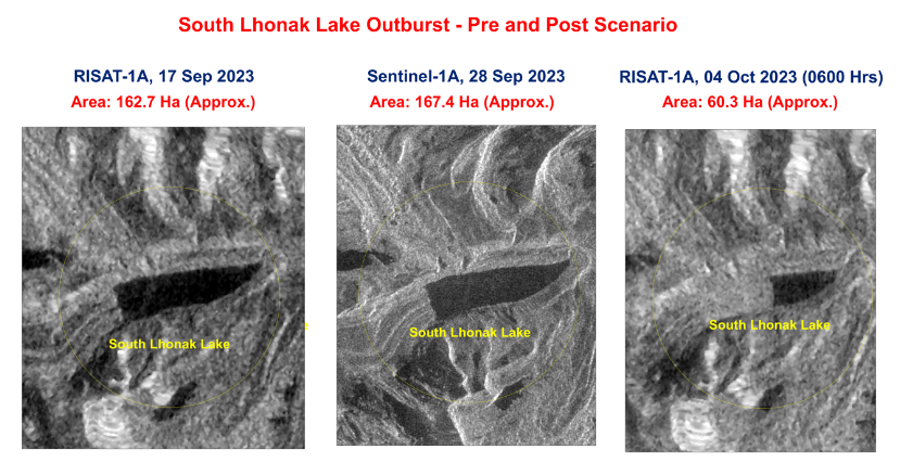
NDMA added that Satellite images received from NRSC (ISRO) reveal that more than half the South Lhonak Lake has been drained out due to the GLOF. The NRSC satellite imagery showed that the lake was spread over approximately 162.7 hectares. Its area increased to 167.4 hectares on September 28 and then drastically reduced to 60.3 hectares. This means water in over 100 acres of area drained out.
The Sikkim State Disaster Management Authority stated that a “cloudburst in portions of Lhonak Lake, which caused the rise of water levels with very high velocities downstream along the Teesta River basin in the early hours of Wednesday.”
This massive amount of water swept away everything in its path, including the dam and the bridges. Rocks and debris carried by the water increased the momentum, causing massive destruction.
Himalayan Glaciers
The Himalayan Ranges have a larger number of glacial lakes, the number of which has been estimated at about 7,500 using remote sensing techniques. Of these, Sikkim has 733 glacial lakes, of which nearly 25 are assessed to be at-risk, as per NDMA. 288 of the lakes are located above an altitude of 5,000. The Teesta River basin alone has 313 glacial lakes.
South Lhonak glacier and the lake are among the ones already identified as at-risk. Scientists at the Indian Institute of Science (IISc) in Bengaluru and the Indian Space Research Organisation (ISRO) had earlier warned that the South Lhonak lake was “potentially hazardous,” asking authorities to keep an eye on it.
Cloudbursts and Glacial lake outburst floods (GLOF) are a major concern in the Himalayan region and have caused disasters earlier, including the Kedarnath disaster in 2013.
As per studies, glaciers in the Hindu Kush Himalaya mountain range could lose up to 75% of their volume by the century’s end due to global warming. Melting of glaciers in the Eastern Himalayas will be faster as per the study by Kathmandu-based International Centre for Integrated Mountain Development (ICIMOD). If this happens, this will mean massive floods followed by serious water shortages.
However, there is a lack of historical record of glaciers in the region, unlike the glaciers in the US or Europe. Therefore, there are high degrees of uncertainties in predictions. But the fact remains that Himalayas face cloudbursts and GLOFs from time to time, causing destruction downstream.
Anti-dam activism
The Sikkim incident gave the anti-dam activists an opportunity to raise their voices against building big dams, especially in the Himalayas. There is a sustained campaign in the country against the construction of dams, due to various reasons such as displacement of people, risks of disasters etc. Such incidents give boosts to such campaigns.
Terrible footages coming out of #Sikkim of the 1200 MW #ChungthangDam being breached.
— kaustubh (@kaustubhdeka) October 4, 2023
Precisely why many have warned about the #Himalayan zone not being suitable for big dams & heavy #infrastructure. But a certain model of 'development' burries such cautions, putting all at risk! pic.twitter.com/U7Y8vgiIlr
However, while the risk with such projects will always be there, it is also a fact that hydel electricity is a vital source of energy that India can’t ignore. A developed India will need lots of electricity. At present most of India’s power need is fulfilled by coal-fired thermal plants. However, due to environmental concerns along with depleting coal reserves, hydel power will play a major role as a source of clean power.
Although there has been massive investment in solar power, the issue of its unavailability of sunlight at night remains, and it will remain till technology for large-scale battery storage is developed. Therefore, other sources of energy can’t be ignored, including hydel power. It remains the most reliable source of clean energy, given the current global backlash against nuclear energy, along with associated technological challenges.
Moreover, there will be risks with every kind of project, but that does not mean one abandons such projects. The Himalayan rivers in India offer huge potential for clean energy, and India can’t afford to not utilise them. To take benefit of this massive source of energy and water, there are steps that can be taken to mitigate and reduce risks.
Steps to mitigate the risks
In fact, the government is already taking steps to prevent disasters caused by such cloudbursts and GLOFs. In order to mitigate the impact of a GLOF event in the Himalayan lakes, the govt is installing early warning systems at the lakes which will provide real-time alerts. An NDMA-led expedition surveyed two at-risk lakes in the first week of September 2023, in order to deploy such warning systems. NDMA has said that it has plans to install early warning systems for real-time alerts at most of 56 at-risk glacial lakes in India.
NDMA added that efforts to expand the mitigation programme are being expedited, while sustained investigations into the causes of this event are underway. Further, as this region is known for highly localised heavy rainfall events, steps are being taken for better predictions. For this, efforts to improve the predictive ability for such events will also be intensified in collaboration with relevant agencies.
Continuous monitoring of the glacial lakes and weather in the mountains is key to preventing such disasters, including proactive response in time by the dam authorities. If the information about glacial lakes overflowing is obtained on time and the gates of dams downstream are opened before the surged water arrives, major disasters can be averted. This may cause flooding in the valley, but will not cause major destruction of infrastructure.
