

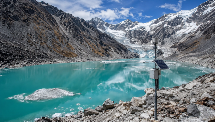
Sikkim has increased preparations for possible flooding from glacier lakes. The development transpired after the National Disaster Management Authority (NDMA) found 40 high-hazard glacial lakes in the state, seven of which were deemed to be at great danger. Notably, the fresh alarm was set off when a devastating flood caused by a glacier in nearby Nepal had already claimed over 1,000 lives and left several others missing.
The Indian state has implemented a multi-layered plan that combines real-time monitoring, scientific assessment, and site-specific mitigating actions in response to the classification of sixteen of these lakes under Category-A vulnerability, while 13 remain unclassified. According to officials, 13 of the 16 priority susceptible lakes, the majority of which are situated at elevations of about 17,000 feet, have undergone thorough scientific evaluation.
“We have more than 400 glacial lakes in Sikkim, both big and small, out of which 16 lakes are highly vulnerable. We are continuously monitoring the lakes, and we have installed sensors in most of the lakes to find out whether the volume of the glacial lake is increasing or not. In many places in North Sikkim, where the lakes are mostly situated, we have installed early warning systems and automated weather stations to inform us about any rise in the water level,” stated Sikkim State Relief Commissioner Rinzing Chewang.
“These systems provide continuous, real-time weather and hydrological data to detect shifts in lake conditions early enough for preventative action before a crisis develops,” outlined Secretary-cum-Principal Director of the Department Dhiren Shrestha.
The examinations focused on lake depth, water volume, moraine stability, and the dangers of avalanches and landslides, according to Sandeep Tambe, principal secretary of Sikkim’s Science and Technology Department. Three significant initiatives have been proposed to decrease the risk presented by some of the most exposed lake systems.
Authorities have suggested employing solar-powered pumps to lower the lake level by 20 to 40 meters at Shako Chu, where about 27 million cubic meters of water are trapped behind a brittle terminal moraine. In the event that the moraine fails, the move would drain about 8 million cubic meters of water from the lake, lowering the amount that might be released downstream.
Officials are researching a stone-masonry retention structure at Dolma Sampang, some 24 kilometres downstream, for the South-North Lhonak cluster. The purpose of the building is to lessen the possible flood’s impact before it reaches downstream places that are more vulnerable. According to officials, the 300-hectare Dolma Sampang region minimised the impact of the 2023 South Lhonak flood. The third plan focuses on the Gurudongmar Lake complex, where authorities are contemplating building a safety wall at the moraine plug to control water discharge without upsetting the holy lake.
While the Brahmaputra Board, Ministry of Jal Shakti, and Central Water Commission are directly involved in mitigation plans at Gurudongmar and other high-risk locations, the National Disaster Management Authority (NDMA) and the Ministry of Home Affairs are supporting recommended steps at Shako Chho. In-depth field research has also supported the state’s preparedness initiative. Over the past two years, five significant missions have been performed by multi-agency scientific teams to map and evaluate GLOF (Glacial Lake Outburst Flood) threats throughout the high-altitude regions of Sikkim.
Officials assured, “Sikkim is actively seeking enhanced coordination across the wider Himalayan belt to mitigate cascading risks from environmental developments and disaster events in neighbouring territories.”