

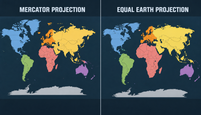
The United States recently opposed a world map that reflected the true relative sizes of countries and continents. It was the only country that voted against a resolution presented and passed in the United Nations General Assembly on Friday (4th September) for the adoption of the corrected world map.
The resolution was introduced following the African nations’ appeal to the UN to fix the traditional world map that wrongly represented the relative size of the African continent. Foreign Minister Robert Dussey of Togo sponsored the “Correct the Map” resolution in the General Assembly, which was backed by the African Union (AU) members.
“A map is never neutral. It shapes perceptions, influences how the place of peoples and continents in the world is understood,” Dussey said while addressing the assembly. “The resolution adopted today reaffirms African reality,” he added.
On Friday, the United Nations General Assembly adopted an African proposal for a new world map, which shows countries’ true size relative to one another.
— UN News (@UN_News_Centre) September 4, 2026
In favor: 164
Against: 1
Abstentions: 6 pic.twitter.com/5BE4LUiojH
According to the resolution, the new world map, referred to as the Equal Earth cartographic projection, “is a relevant option for improving the accuracy of the cartographic representation of the world”. It says that the existing map not only distorts the sizes of the continents but also diminishes the global perception with respect to the true physical presence of Africa, Latin America, and South Asia on the face of the Earth.
The resolution states that the distortions “contribute to minimizing the extent of socioeconomic realities, infrastructure needs, development potential, and prosperity in the Southern regions, and that they can fuel prejudices in the environmental, geopolitical, and security fields.”
The Equal Earth map was almost unanimously adopted by the member countries in the General Assembly. Out of all 165 member countries that voted on the resolution, 164 voted in its favour while only the United States voted against it. Six countries abstained from voting on the resolution.
Congratulations to the delegation of #Togo 🇹🇬 and the Africa Group on the adoption this morning by the #UNGA of resolution A/80/L.104, “Correct the Map.”
— African Union (@_AfricanUnion) September 4, 2026
First endorsed by the African Union Assembly in February and officially passed at the United Nations today, this… pic.twitter.com/wHxblZ8d3K
Even though the resolution is non-binding, it is likely to replace the Mercator map being used by governments and institutions across the world with the new map having accurate representations. The reason why the Mercator map, which has been in use since the 16th Century, was opposed by the African nations is that it misrepresents the size of the African continent in comparison to other continents. The map shows the size of Africa as similar to Greenland, while in reality it is 14 times larger.
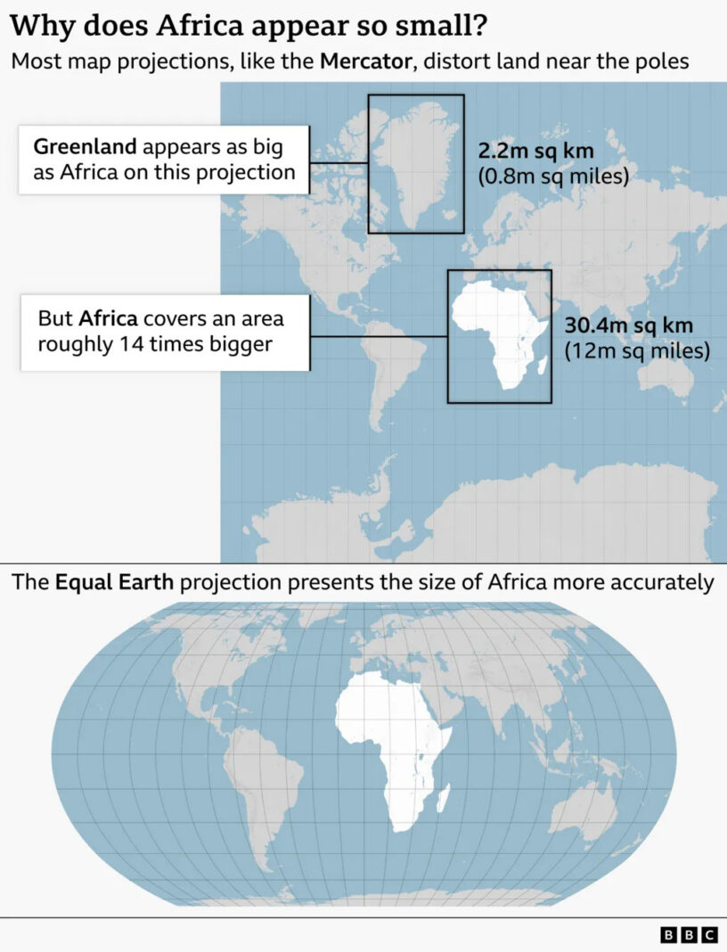
Many of the maps currently in use across the world are based on the Mercator projection, which was created by European cartographer Gerardus Mercator in 1569. The map accommodates the curvature of the Earth by making countries near the equator appear smaller than they are, and the countries nearer the poles appear larger.
So, for example, on the map, Greenland, which is close to the North Pole, looks bigger than the African landmass, which is on the Equator. Greenland is roughly the size of the Democratic Republic of the Congo, which is one of the 54 countries in the African continent.
Ironically, in reality, Africa has around 30.3 million square kilometres (11.7 million square miles) of land area, which can accommodate the US, China, India, and most of Europe.
To address the distortion in the sizes of continents, a team of cartographers created the Equal Earth projection in 2018. The Equal Earth map was adopted by the 54 members of the African Union in February this year, stating that it “more accurately represents the sizes of all continents, particularly Africa”.