HomeGovernment and PolicyNew map demarcating Union Territories Jammu and Kashmir and Ladakh released by the Centre

New map demarcating Union Territories Jammu and Kashmir and Ladakh released by the Centre

The released map puts in perspective the move to hollow out Article 370, that served as an impediment to the greater integration of state and its population into the Union of India. With the reorganisation of the state into two union territories, the government plans to harness their developmental potential and bring them at par with the rest of the country.

A new political map showing the administrative boundaries of the newly carved out union territories-Jammu and Kashmir and Ladakh has been released by the Central government. The Indian Union now consists of 28 states and 9 union territories. The bifurcation of Jammu & Kashmir into two Union Territories came into effect at midnight on October 30.

Political map of India (Union Ministry of Home Affairs)

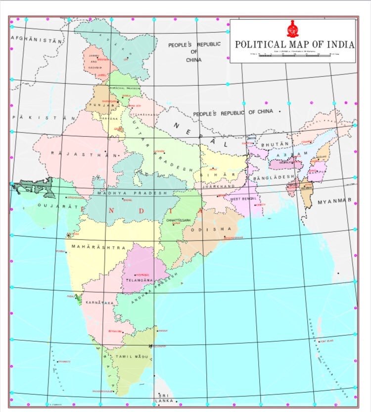
The new map of the Indian Union, as released by the Home Minister, shows erstwhile Jammu and Kashmir state divided into two parts- Jammu along with Kashmir valley and parts of Pakistan occupied Kashmir as a separate union territory with distinct boundaries, while Ladakh, Kargil, including Gilgit-Baltistan which is under forcible occupation of Pakistan, are categorised under Ladakh union territory.

Recently, Lieutenant Governors were appointed to take charge of newly formed union territories of Jammu and Kashmir and Ladakh. GC Murmu was anointed as the Lt-Governor of Jammu and Kashmir while RK Mathur was sworn in as the first Ladakh Lt-Governor.

Read: Doob Maro: PM Modi to those casting aspersions and linking abrogation of Article 370 to Maharashtra polls

On August 5, the Narendra Modi-led BJP government at the centre took a historic decision of abrogating Article 370, stripping away the separate status of Jammu and Kashmir state, and subsequently got the Jammu and Kashmir Reorganisation Bill passed to bifurcate the state into two union territories- Jammu and Kashmir and Ladakh.

The released map puts in perspective the move to hollow out Article 370, that served as an impediment to the greater integration of state and its population into the Union of India. With the reorganisation of the state into two union territories, the government plans to harness their developmental potential and bring them at par with the rest of the country.

Join OpIndia's official WhatsApp channel

  Support Us  

For likes of 'The Wire' who consider 'nationalism' a bad word, there is never paucity of funds. They have a well-oiled international ecosystem that keeps their business running. We need your support to fight them. Please contribute whatever you can afford

OpIndia Staff
OpIndia Staffhttps://www.opindia.com
Staff reporter at OpIndia

Related Articles

Trending now

‘BJP swallows its allies’: Old accusation is back after Annamalai’s departure, but It’s the allies who backstabbed BJP first

Despite Annamalai leaving the party, it does not prove that BJP abandons its leaders or allies. History shows BJP’s coalition politics has been the strategy of taking allies along.

As Congress and AAP fight to take credit for developing the ‘education sector’ of Punjab, read how Arvind Kejriwal was accused of passing Sheila...

While AAP has claimed credit for Punjab’s rise in the education sector, the timeline suggests the state’s improvement may have begun before the party came to power in 2022. The AAP government was sworn in in March 2022. But some key surveys or studies have cited the data prior to 2022. It raises the question: Does the AAP government deserve the actual credit, or are they riding on someone else's work? 
- Advertisement -