
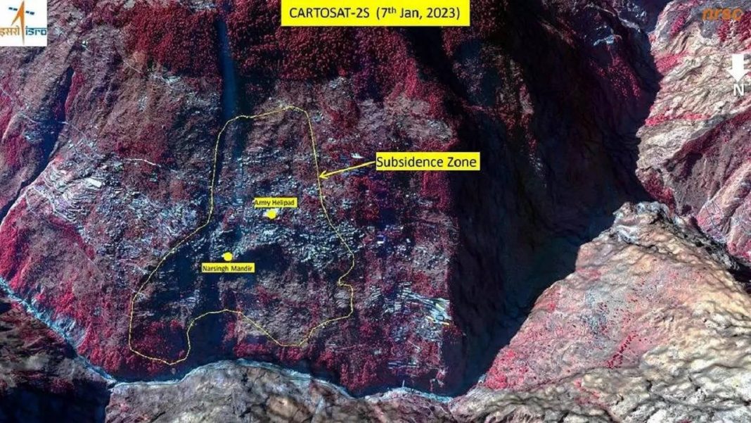
The National Remote Sensing Centre (NRSC) of the Indian Space Research Organisation (ISRO) has released satellite images and a preliminary assessment of the catastrophe underway at Joshimath. The pictures and report warn that the entire Joshimath may be susceptible to sinking.
Taken from Cartosat-2s satellite, the Hyderabad-based NRSC released satellite images of the areas that are sinking. The images show that the entire town of Joshimath, including the Army’s helipad and the Narasimha temple, has been marked as a sensitive zone.
The Uttarakhand government has initiated a rescue operation based on ISRO’s preliminary report, evacuating people living in sensitive regions to safer places.
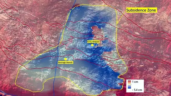
As per the report, the land subsidence was slow between April and November 2022, during which Joshimath had sunk by 8.9 cm. However, between December 27, 2022, and January 8, 2023, the pace of land subsidence escalated and the town sank by 5.4 cm in these 12 days.
The images also showed that the Joshimath-Auli road is going to collapse due to land subsidence.
While the scientists are still assessing the cracks that appeared in the houses and roads after the land subsidence in the town, the primary reports of ISRO and the satellite images have had the authorities concerned.
Although scientists are still studying the cracks that appeared in the houses and roads after the land subsidence in the town, the findings in the primary report of ISRO are frightening.
Why is Joshimath sinking?
Joshimath is located on the middle slopes of the hill, bounded on the west and east by Karmanasa and Dhaknala, respectively, and on the other sides by Dhauliganga and Alaknanda.
With increasing urbanization, this small Himalayan town has come under increased strain. According to the researchers, urbanization has historically aggravated these issues because it disrupts natural water drainage, slopes, and results in an uncontrolled flow of water.
According to the District Disaster Management Department, 561 houses in Joshimath have developed cracks due to the continued subsidence of land. So far, more than 66 families have reportedly migrated from Joshimath.
