
Gujarat, the western state of India, is known for having the longest coastline in the country. According to recent data, the length of Gujarat’s coastline has increased significantly. Earlier, Gujarat’s coastline was estimated to be about 1,600 kilometers, but now it is recorded as 2,340.62 kilometers. That means an increase of about 700 kilometers.
It is worth mentioning that Gujarat’s coastline was measured at 1,214 kilometers in the year 1970, later it was increased to 1660 kilometers, then to 1945 kilometers. Thus, Gujarat’s coastline has almost doubled to 2,340 kilometers in the last 53 years. Why this significant increase? Has Gujarat’s coastline really increased geographically? Or is this just a result of measurement accuracy? Let’s find out the real answer to these questions.
Increase in the length of the coastline! How?
The increase in the length of Gujarat’s coastline is the result of new methods of accurate measurement and calculation rather than geographical expansion. The Government of India has used new technology and methods to calculate the length of the coastline. In which, technology, including the help of satellites, has been utilised. Lets look at all these methods in detail.
Geographic Information System (GIS): GIS software (such as ArcGIS, QGIS) was used to digitally trace the coastline. This method included fine details (such as the Gulf of Khambhat, the Gulf of Kutch) at a scale of 1:10,000.
Satellite Imagery (Sentinel-2, Landsat-9): High-resolution images from the Sentinel-2 and Landsat-9 satellites were used to delineate the land-water boundary. The boundary between water and land was identified using the Normalized Difference Water Index (NDWI). Sentinel-2 data provides an accuracy of 5-10 meters.
LiDAR (Light Detection and Ranging): LiDAR is a laser-based technology that delineates a precise line based on the topography of the coastline and the mean high water level (Mean High Water). The accuracy of 1-2 meters with it covers even small bends and estuaries.
Fractal Analysis: The fractal dimension (complexity) of the coastline was measured using box-counting and divider methods. This method includes more details at smaller scales, which helped measure the coastline accurately.
Inclusion of Gulfs and Islands: Gujarat’s coastline includes the Gulf of Kutch, the Gulf of Khambhat, and about 144 small islands. The new calculations also take into account the length of the coastlines of all these bodies.
More detailed measurements: In the previous calculations, the coastline was measured using a straight-line approximation. Now, every small bend, groove, and estuary of the coastline has been included.
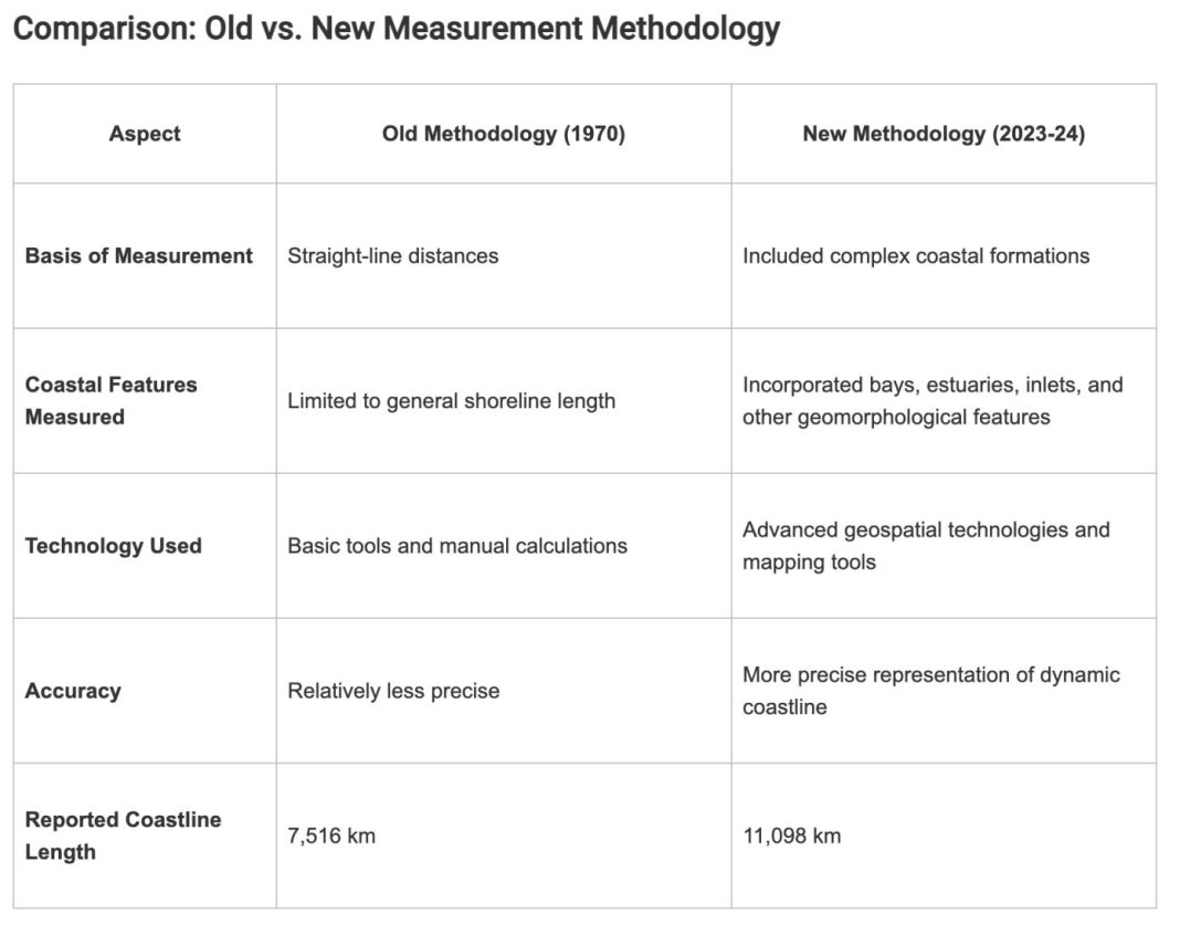
Due to these advanced methods, the length of Gujarat’s coastline has increased by about 700 kilometers. This change is not limited to Gujarat, the total length of India’s coastline has also increased from 7,517 kilometers to 11,098.81 kilometers.
Features of Gujarat’s coastline
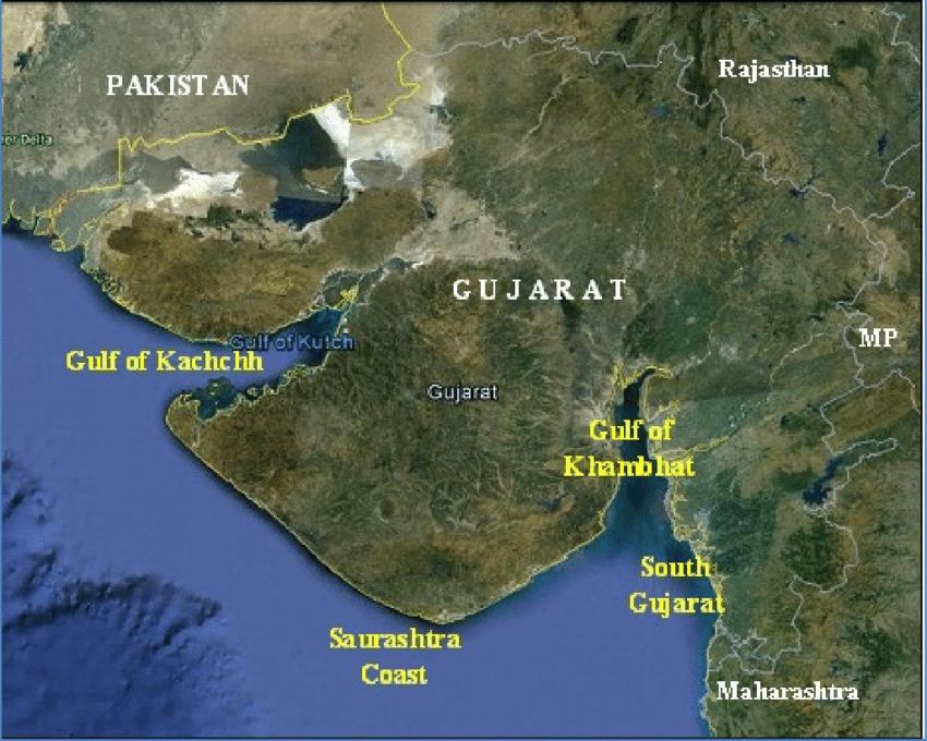
Gujarat’s coastline accounts for about 21% of India’s total coastline, making it the state with the longest coastline in the country. This coastline has various geographical features.
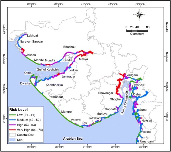
For example, the Gulf of Kutch in north-west Gujarat contributes significantly to the length of the coastline. Its numerous small islands and their complex coastlines contribute a lot to the length. The Gulf of Khambhat in south-east Gujarat has also contributed significantly to the length of the coastline.
In addition, there are many small and large islands near the coast of Gujarat, such as Diu, Bet Dwarka, and other small islands. The length of the coastlines of these islands has also been included in the count. Apart from this, rivers of Gujarat such as Narmada, Tapi, and Sabarmati meet the Arab Sea, which form estuaries. The length of these estuaries has also been added to the count of the coastline.
These variations make Gujarat’s coastline extremely complex, and new technology has made it possible to measure this complexity more precisely.
Why did the measurement change
Coastline Paradox
The process of measuring the length of a coastline is linked to a mathematical problem called the ‘Coastline Paradox’. According to this principle, the length of a coastline depends on the scale at which you measure it. If you use a 1:100,000 scale, the coastline appears smooth and the length is reduced.
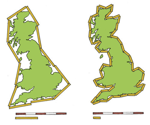
But if you use a 1:1,000 scale, then every little curve, notch, and detail of the bay is included, which increases the length significantly. In the case of Gujarat, the new calculations used a much smaller scale, resulting in an increase in the length of the coastline.
Earlier, maps, field surveys and manual calculations were used to measure the length of the coastline. These methods had limitations in accuracy. Now, satellite imagery, drone technology and GIS software are used, which provide very precise and detailed measurements.
Does this mean that Gujarat’s land has shrunk
No, this increase in the length of the coastline is not the result of geographical land subsidence or coastal expansion. This is only the result of the accuracy of the calculations. Because here the question is about the increase in coastline. Here the coastline means the part where the sea and the land meet. It is a matter of common sense that the coastline increases only if both of them increase. But here again we will draw your attention to the same thing that no length has increased geographically, only the modern method of measuring length has brought these new distance figures to light.
What is the importance of accurate measurement of Coastline
This increase in the length of Gujarat’s coastline is not just a statistical change; it has many practical and policy implications. Gujarat’s coastline is important for ports, fisheries, and tourism. Accurate measurements will help in the planning and development of these activities. Knowing the exact length of the coastline will allow better plans to be made to deal with erosion, flooding, and the effects of climate change.
Accurate data for coastal development, protection, and management will help the government formulate more effective policies. Accurate measurements are important for geographical, environmental, and climatic studies of the coastline. It is noteworthy that the Government of India has also broadened the definition of coastline in the new census. For example, the length of estuaries, inlets, and tidal zones was also included, which was not considered much previously.
Increase in the coastline of other states as well
This increase is not limited to Gujarat alone, but there has been a significant increase in the length of the coastline of the entire India. According to the data, the total coastline of India has increased from 7,517 km to 11,098.81 km. This increase is also a result of new measurement methods, satellite imagery, and more accurate calculations, which include the complexities of the coastlines of all the coastal states and union territories of the country.
According to the data presented in Rajya Sabha, the coastline of Andhra Pradesh has increased from 973.7 km to 1,779.91 km, that of Tamil Nadu from 1,076 km to 1,346.16 km, that of Maharashtra from 652.6 km to 1,213.08 km, and that of Odisha from 480 km to 671.12 km. Among the Union Territories, the coastline of Andaman and Nicobar Islands has increased from 1,962 km to 2,316.30 km. This increase is also due to the use of accurate measurements and new technology.
All this just means that Gujarat’s coastline has not increased geographically, but its exact length is now recorded more accurately.
The original Gujarati report explaining this can be read here.
