

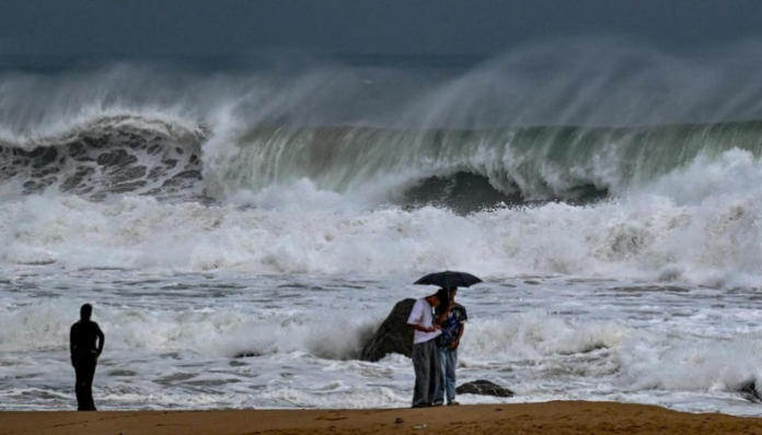
India’s southern coast has seen the landfall of Cyclone Arnab. Thousands of people were evacuated from Andhra Pradesh and Odisha. It triggered widespread alerts from the national capital down to the eastern seaboard. The storm, classified as a “very severe cyclonic storm,” has brought ferocious winds and torrential rain. So far, at least three people have lost their lives.
#WATCH | Andhra Pradesh: Very strong winds and heavy rainfall in Amalapuram in Konaseema district as an impact of Cyclone Arnab. (Video Source: Andhra Pradesh I&PR) https://t.co/E1jMR5asRd
— ANI (@ANI) October 27, 2026
The threat of significant flooding looms over some of India’s most densely populated coastal regions.
Here is a breakdown of the cyclone, its origins, its impact, and the massive preparedness effort it has prompted.
#WATCH | Andhra Pradesh: Very strong winds and heavy rainfall in Amalapuram in Konaseema district as an impact of Cyclone Arnab. (Video Source: Andhra Pradesh I&PR) https://t.co/E1jMR5asRd
— ANI (@ANI) October 27, 2026
What is Cyclone ‘Arnab’ and why did it form?
Cyclone Arnab is a powerful tropical cyclone that formed over the Bay of Bengal. According to the India Meteorological Department (IMD), it intensified into a cyclonic storm on 26 October and ultimately made landfall as a “very severe cyclonic storm” near Yanam, close to Kakinada in Andhra Pradesh, during the early hours of 28 October. At its peak, the storm packed maximum sustained wind speeds of 125–135 kmph, with gusts reaching up to 150 kmph.
Bangladesh proposed the name “Arnab” to the official list of tropical cyclone names for the North Indian Ocean. The word is commonly associated with the “ocean” or “sea” in Bengali. The naming system, coordinated by the World Meteorological Organisation (WMO), uses a pre-approved list of 169 names contributed by 13 countries, assigned sequentially to storms as they develop.
It originated from a low-pressure area in the eastern Bay of Bengal that gradually consolidated and intensified. Its main fuel was abnormally warm sea surface temperatures, which exceeded the 26°C threshold considered favourable for cyclone development. The absence of strong atmospheric wind shear allowed the system to organise and strengthen without being torn apart. Climatologically, the storm’s formation aligns with conditions typical of an El Niño year. It is marked by abnormal warming of the equatorial Pacific, which can influence cyclone activity in the Indian Ocean.
How is it impacting Indian states and cities?
The impact has been most severe in Andhra Pradesh, where landfall occurred. Coastal districts including Anakapalli, Visakhapatnam, Kakinada and Konaseema have been battered by extremely heavy rain. Kannuripalem in Anakapalli recorded 259 mm of rain, while wind speeds of 130 kmph were recorded at Maruteru. Kakinada experienced severe conditions, with heavy waves, uprooted trees and disrupted power lines. Storm surges of up to 2.5 metres were warned for near Kakinada and Yanam (Puducherry).
Odisha has faced heavy to very heavy rainfall in southern districts including Gajapati, Ganjam, Rayagada, Koraput, Nabarangpur and Malkangiri. The IMD and disaster authorities also flagged Telangana, Chhattisgarh and Yanam (Puducherry) for heavy rain and potential flooding. Eastern Uttar Pradesh and Bihar were placed on alert as the system moved inland. Parts of West Bengal, including Kolkata, felt indirect effects through strong moisture incursion and changed weather.
How Prepared Were the States?
The National Crisis Management Committee reviewed preparedness and directed central agencies and states to minimise damage.
Andhra Pradesh earmarked ₹27 crore for emergency relief and identified 2,199 cyclone shelters. Over 2,360 pregnant women were shifted to medical facilities, more than 84,000 people were evacuated to 290 relief shelters, and at least 609 schools became rehabilitation centres. NDRF and SDRF teams were deployed, with police, fire and medical teams and the Navy and Coast Guard on standby.
Odisha closed schools, colleges and Anganwadi centres in six vulnerable southern districts on 28-29 October, banned fishing and restricted tourist entry to hills, waterfalls and dams. It deployed NDRF and ODRAF teams, focusing on shifting people in thatched houses and low-lying areas.
NDRF deployed 31 teams across India. 12 teams deployed in Andhra Pradesh, nine in Odisha, four in Chhattisgarh, four in Telangana and two in Yanam, with 72 SDRF teams in affected areas. The Army, Navy, Air Force and Coast Guard kept rescue teams, ships and aircraft ready. As the storm weakens inland, focus shifts to restoring power, clearing roads and assessing damage, but the large pre-landfall evacuation appears to have been crucial in protecting lives.