
In another bold step towards Aatmanirbhar Bharat, Indian Space Research Organisation (ISRO) and MapmyIndia, the navigation solutions provider, have teamed up to build an alternative to Google maps. It will be developing a fully indigenous, made-in-India mapping portal and geospatial services.
MapmyIndia CEO and Executive Director, Rohan Verma took to LinkedIn on Friday to announce the initiative. Verma said that both the organisations would come with an India made mapping portal and geospatial services. Verma added that the collaboration will boost Aatmanirbhar Bharat, where, in the future, the users in India can rely on a made-in-India solution and not a service designed outside India. “You don’t need Goo*le Maps/Earth any longer”, Verma wrote in his LinkedIn post.
ISRO confirmed that the Department of Space (DoS) has joined hands with MapmyIndia to combine their geospatial expertise and build holistic solutions by leveraging their geoportals. On February 11 (Thursday), DoS signed a memorandum of understanding MaymyIndia parent CE Info Systems Pvt. Ltd.
Department of Space (DOS) has entered into an MoU with M/s CE Info Systems Pvt Ltd today. This will enable DOS and CE Info Systems to jointly identify and build geospatial solutions.
— ISRO (@isro) February 11, 2021
More details: https://t.co/GVJBwgPBy8@MapmyIndia #ISRO pic.twitter.com/NClryE9pHh
The official website of ISRO confirmed that Shri R Umamaheswaran, Scientific Secretary, ISRO, signed the MoU on behalf of DOS and Rakesh Verma, CMD, M/s CE Info Systems Pvt Ltd signed from MapmyIndia’s side.
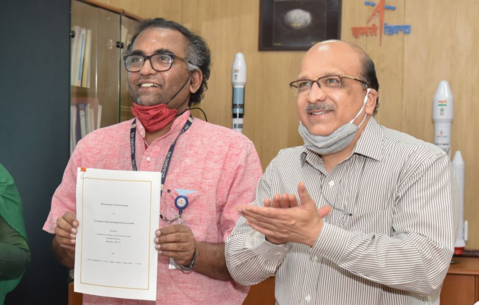
Elaborating about the partnership, ISRO in a statement said: “The collaboration will enable them to jointly identify and build holistic geospatial solutions utilising the earth observation datasets, “NavIC”, Web Services and APIs (application programming interface) available in MapmyIndia, “Bhuvan”, “VEDAS” and “MOSDAC” geoportals.”
Speaking of the advantages of having a country made mapping and geospatial service, MapmyIndia CEO Rohan Verma said: “MapmyIndia, being a responsible, local, Indian company, ensures that its maps reflect the true sovereignty of the country, depicting India’s borders as per Government of India, and hosts its maps in India.”
Through the combined partnership with ISRO, MapmyIndia’s end-user maps, apps and services will now integrate with ISRO’s huge catalogue of satellite imagery and earth observation data.
Google maps face criticism for tampering with the map of India
It is pertinent to note here that the popular search engine, Google maps came under severe criticism in February last year when it redrew the Kashmir’s borders making it appear different when searched from outside India. It showed Kashmir’s outlines as a dotted line acknowledging “dispute” when it is viewed from outside India.
It was then reported, that the borders on Google’s online maps displayed Kashmir as an integral part of India when viewed from India, contrary to what it appeared when seen from elsewhere. For example, when viewed from Pakistan, the Kashmir region had appeared disputed marked with dotted lines.
Earlier in 2013, Google Maps had come under criticism for showing PoK and Aksai Chin (and parts of Arunachal Pradesh) outside the Indian map, and the then government had asked it to correct it.
