
On Thursday (25th January), Congress spokesperson Lavanya Ballal Jain took to X (formerly Twitter) to take potshots at right-wing intellectuals over the findings of the Archaeological Survey of India (ASI) from the site of the disputed Gyanvapi mosque.
While doing so, she ended up exposing her ignorance about the workings of ASI. Lavanya assumed that the survey conducted by the Archaeological Survey of India was somehow similar to online surveys and not ‘real’ archaeological findings.
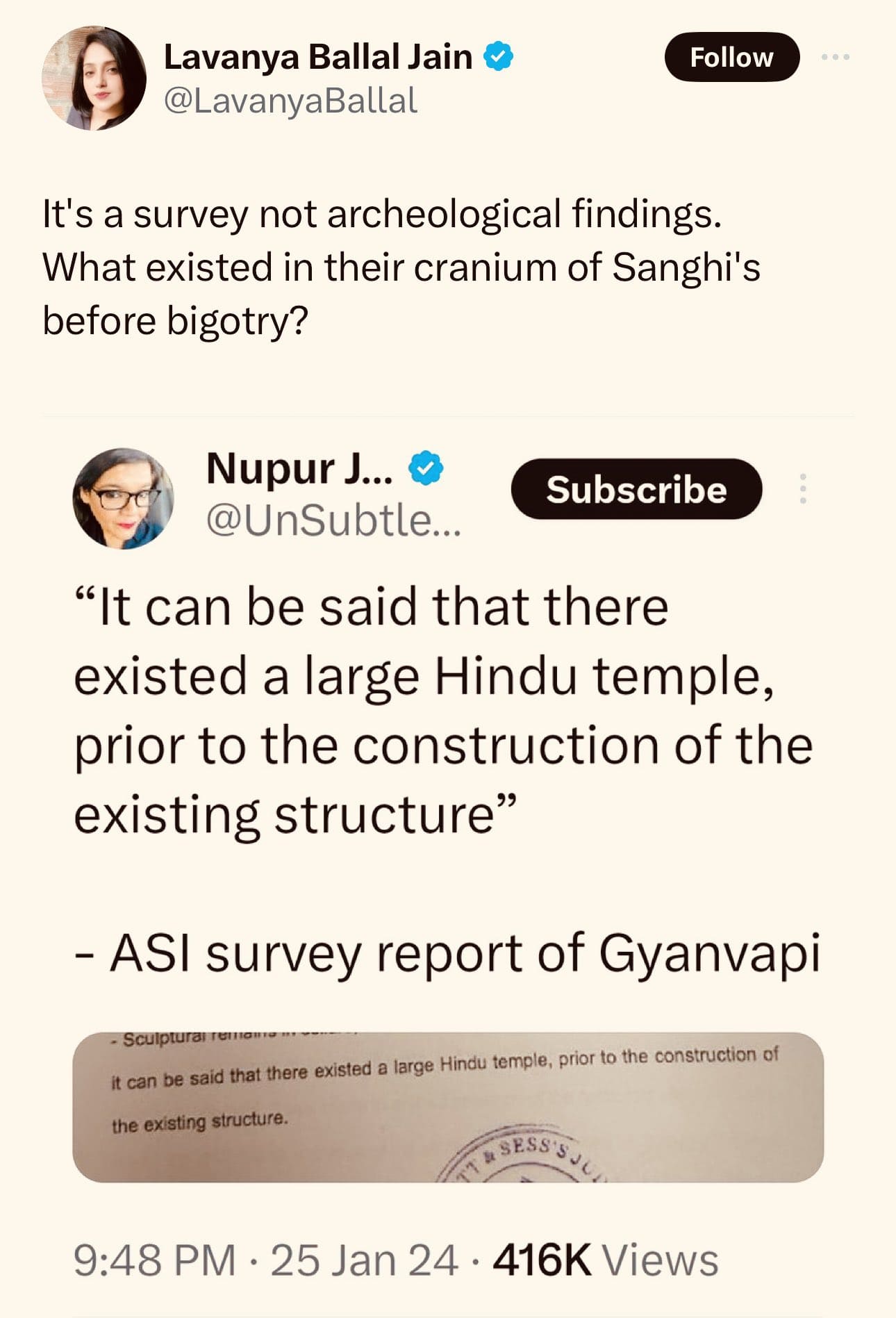
In a tweet (archive), she brazened out, “It’s a survey not archaeological findings. What existed in their cranium of Sanghi’s before bigotry?” The development came after ASI in its 850-page report revealed that a large Hindu temple existed at the site of the disputed Gyanvapi mosque.
While the Congress spokesperson wanted to downplay the findings of ASI and negate the fact that the mosque was built on the ruins of a Hindu temple, she ended up revealing her sheer lack of comprehension skills.
Nonetheless, social media users did not mince words before taking potshots at the ignorance of Lavanya Ballal Jain.
One Darshan Pathak posted the screenshot of a dubious, phishing online survey and asked the Congress spokesperson, “Did she really think it is one of these surveys?”
Did she really think it's one of them surveys? ? pic.twitter.com/bB23jpZ40z
— Darshan Pathak (@darshanpathak) January 27, 2024
“Seriously, are you really this stupid? Do you think this is a market survey done by public? You come across as a consistent dunce #Lavanya BJ,” inquired one X user.
Seriously, are you really this stupid? Do you think this is a market survey done by public? You come across as a consistent dunce. #LavanyaBJ
— Pavanasoonu ?? (@Pavanasoonu) January 27, 2024
One Inder J Gusain questioned, “Do you think it was a market survey by NYT with a sample size of 6700?”
Do you think it was a market survey by NYT with a sample size of 6700? ?
— Inder J Gusain (@OfficialInderJ) January 27, 2024
“The A in ASI stands for Archaeological, Lavanya,” one X user gave the Congress spokesperson a lesson in common sense.
The A in ASI stands for Archeological, Lavanya.
— Brutal Truth (@sarkarstix) January 27, 2024
Renowned advocate Shashank Shekhar Jha shared a meme, which stated, “Kid, if you have put your intelligence to sleep, then, allow your mouth to rest too.”
— Shashank Shekhar Jha (@shashank_ssj) January 27, 2024
“Now she proved that her leader is Pappu Rahul Gandhi,” tweeted another user.
???
— Gaurav?? (@IamGMishra) January 27, 2024
Now she proved that her leader is Pappu @RahulGandhi
Archaeological survey in the context of the disputed Gyanvapi mosque
An archaeological survey is a systematic and organised method used by archaeologists to locate, identify, and record archaeological sites and artefacts within a particular area. This method helps researchers gain valuable information about past civilizations and cultures.
The goal is to identify and document any potential archaeological resources. One such survey conducted by the Archaeological Survey of India (ASI) at the site of the disputed Gyanvapi mosque revealed the existence of a large temple.
Congress spokesperson Lavanya Ballal Jain had insinuated that the research work undertaken by the Archaeological Survey of India at the disputed Gynavapi mosque was somehow not actual scientific finding but an opinionated survey of sorts devoid of scientific temperament.
However, nothing possibly could be farther from the truth. The ASI team used several scientific instruments for conducting their research. Those included Differential Global Positioning System (DGPS), Total Station, Electronic Distometre, GPS Map 76CSX, Handheld X-Ray Fluorescence (XRF) and Thermo-hygrometer.
The ASI team employed scientific methodologies to reach their conclusion, which has been detailed in its 850-page report. As stated in Volume 2 (Pages 9-14) of its report, the techniques include:
Ground Penetrating Radar:
This geophysical method played a significant role in the survey due to its non-invasive and non-destructive nature. ASI was able to generate high-resolution imaging, identifying and mapping buried foundation walls within the ancient ruins of the pre-existing temple.
The precise sub-surface mapping helped reduce the risk of inadvertent damage to the ancient structure.
Differential Global Positioning Systems (DGPS):
DGPS is an enhanced version of the Global Positioning System (GPS), which is used in archaeological surveys. It improves the accuracy of location data obtained from GPS by correcting the GPS signals for various sources of errors.
In a standard GPS system, errors can occur due to factors such as atmospheric conditions, satellite clock inaccuracies, and signal reflections. DGPS minimises these errors by using a network of stationary ground-based reference stations. These reference stations precisely measure the difference between the actual position and the position calculated by GPS satellites.
Total Station Survey:
It is an electronic instrument used in archaeology to measure distances, angles, and coordinates with a high level of accuracy. It combines the functions of a theodolite (for measuring angles) and an electronic distance measuring (EDM) device into a single unit. Total stations are equipped with data logging and data transfer capabilities and some have auto-tracking capabilities.
Handheld X-Ray Fluorescence Spectrometer:
XRF is an instrument used for non-destructive elemental analysis of materials. It is a valuable tool in various fields, especially archaeology. The technology relies on the principle of X-ray fluorescence to determine the elemental composition of a sample.
XRF is compact, lightweight, and portable. It provides quick results, allowing for efficient decision-making in the field or on-site. XRF analysis is non-destructive i.e.it does not damage the sample.
Thermo-hygrometer:
It is used to record humidity and temperature during working hours.
Radiocarbon dating:
Radiocarbon dating (C-14 dating) is a widely used archaeological method used for determining the age of an object. It measures the amount of carbon-14 present in an organic material. It was developed by Willard Libby in the late 1940s.
The method is highly effective for dating materials up to around 60,000 years old. However, it is not suitable for dating materials that are millions of years old, as the amount of carbon-14 becomes too small to measure accurately.
Interestingly, radiocarbon dating provides dates in radiocarbon years, which then need to be converted to calendar years. For this task, archaeologists need to account for fluctuations in atmospheric carbon-14 levels over time.
Thermoluminescence Dating:
Thermoluminescence (TL) dating is used in archaeology to determine the time elapsed since certain minerals were last exposed to daylight or heated. It is particularly useful for dating pottery, ceramics, burnt stones, and other materials that contain crystalline minerals.
The principle behind thermoluminescence dating is based on the fact that some minerals, such as quartz and feldspar, accumulate energy in the form of trapped electrons over time when they are exposed to ionizing radiation from natural sources.
This trapped energy is released when the minerals are subjected to heat, typically during the firing of pottery or when they are exposed to sunlight.
Isotopic Dating
Isotopic dating is used to determine the age of artefacts based on the decay of radioactive isotopes. This technique relies on the principle that certain isotopes decay at a known and constant rate over time.
The basic idea behind isotopic dating is to measure the ratio of parent isotopes to daughter isotopes in a sample. The parent isotope undergoes radioactive decay into a stable daughter isotope.
By measuring the ratio of parent to daughter isotopes, archaeologists can estimate the amount of time that has passed since the rock or mineral formed. Isotopic dating provides absolute ages, which makes it a powerful tool in understanding archaeological history.
Typological dating:
The method is used in archaeology to establish the chronological order of artefacts based on their typological characteristics. Typology refers to the systematic classification of artefacts into types/ categories based on shared characteristics such as form, style, decoration etc.
This method assumes that artefacts of one particular type were produced during a specific period and that these types could be used to create a relative chronological sequence. It is important to note that typological dating provides a relative chronology rather than absolute dates.
Thus contrary to the claims of Lavanya Ballal Jain, the ‘survey’ and ‘archaeological findings’ of the Archaeological Survey of India is one and the same thing.
It was a meticulous task executed by trained archaeologists with the latest advancements in science and technology and not an online survey that requires no application of intelligence and scientific spirit (as believed by the Congress spokesperson).
Findings of Arcaheological Survey of India
OpIndia has accessed relevant pages of the report, which states that it can be said that there existed a large Hindu temple, prior to the construction of the existing structure.
The study stated that for the reuse of pillars in the existing structure, vyala figures carved on either side of the lotus medallion were mutilated and after removing the stone mass from the corners that space was decorated with floral design. This observation was supported by two similar plasters still existing on the northern and southern walls of the western chamber in their original place.
“The pre-existing structure appears to have been destroyed in the 17th century, during the reign of Aurangzeb, and part of it was modified and reused in the existing structure. Based on scientific studies/ survey carried out, study of architectural remains, exposed features and artefacts, inscriptions, art and sculptures, it can be said that there existed a Hindu temple prior to the construction of the existing structure,” the report stated.

As per the ASI report, the pre-existing Hindu temple had a big central chamber and at least one chamber to the north, south, east and west respectively. Remains of three chambers to the south and west still exist but the remains of the chamber to the east and any extension of it could not be ascertained physically, as the area is covered under a platform with stone flooring.
The ASI report also gave details of the instructions found in the structure that prove the existence of a Hindu temple. During the survey, a number of inscriptions were noticed on the existing and pre-existing structures. A total of 34 inscriptions were recorded during the present survey and 32 estampages were taken.
The report concluded by saying that based on scientific studies/ survey carried out, study of architectural remains, exposed features and artefacts, inscriptions, art and sculptures, it can be said that there existed a Hindu temple prior to the construction of the existing structure.
